I saw the Milky Way the previous night. It was brilliant.
It was lights out early on that 2nd night. I had no problem getting to sleep as I fell into a deep deep slumber (accompanied by purportedly loud breathing) exhausted by the rigors earlier that day.
We awoke to this splendid scenery the next morning. Little did I know there was a glacier hanging around the neighbourhood. Did you catch the joke? Hanging glacier? Ok, my bad... no more geomorphological jokes.
After an extended breakfast (the usual 3 packages of instant oatmeal), we slowly made our way up the meadows of the Rockwall Pass. The cabin is just behind the forest in the background. If you look closely, the trail is on the right edge of the photo. Looks like a posse is after us.
With in minutes we reached the Wolverine Pass junction. The Pass was to the left. The sign said 0.5 km but I doubt is was more than 100 m away.
The summit of the pass demarcated the Kootenay National Park boundary. Remarkably, it was the only passage leading westwards along the Rockwall.
Larry and Ahmed soaking up the scenary on the summit ridge.

Looking westward from Wolverine Pass. Plenty of clear cutting in the valley to the west. It's amazing how these types of developments encroach so closely upon the national parks.
Looking east towards Rockwall Pass and Banff National Park in the distance.
Looking back south towards the now dwarfed Wolverine Cabin.
More wildflowers on Rockwall Pass...
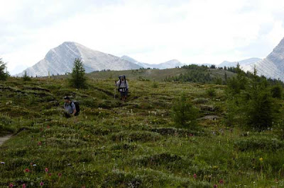
The meadows beyond the cabin seemed to stretch onwards for at least a couple hours. Glorious walking...
Ahmed checking out the massive western limestone wall that dominated the scenery the entire way to Helmet Creek. Between the wall and the alpine meadows was an equally massive glacier-with-no-name.
Eventually, we would take the plunge down towards the glacier-with-no-name. We would stop here for lunch.
After lunch we mounted the spine of the lateral moraine which took us down to a small lake at the foot of a terminal moraine. From that point, the trail climbed skyward taking us right over the tree covered mountain in the background.


The final big climb...
Nearing the summit... Once reaching the peak, we'd finish off the day with a last knee busting 435 m descent into the Helmet Creek Valley.
Most of the descent was through old growth forest but there was the occasional glimpse of spectacular Helmet Falls.
Larry making his way across the bridge to Helmet Creek Cabin...home sweet home for the next two nights...
Monday, September 28, 2009
Hiking The Rockwall Trail, Kootenay National Park (British Columbia) - Day 3 - From Heaven to Hell and Back Again...
Saturday, September 19, 2009
Hiking The Rockwall Trail, Kootenay National Park (British Columbia) - Cabin on the Meadows

We got here so late last night, at first, we couldn't find the loo in the dark. I had to dig a hole... Ok, I'll spare you further details.
The outhouse turned out to be a pre-formed seat made of green plastic over a hole in the ground. No walls, or roof. Rudimentary loo, but the view out the "front door" was of the spooky Devil's Thumb-like mountain in the background. Not bad a view, eh? Sit back and relax...
Wolverine Patrol Cabin was home for the night. It was beautifully situated on the Rockwall Pass meadows.
Larry fixing up some flapjacks. Mmmm...flapjacks... Sure beat the 3 packages of instant maple spice flavoured oatmeal I had planned for brekkie that morning. In fact, it was the only thing on my breakfast menu all week long. I ought to learn how to cook one day.
Varmint... some kind of ground squirrel. Gee, what do they feed them up here? That critter's jumbo-sized.
"The Backyard". The trail went right over the ridge in the background towards Helmet Creek, the final stop on the circuit.
View Larger Map
Green arrow marks the Wolverine Patrol Cabin...
Sunday, September 13, 2009
Hiking The Rockwall Trail, Kootenay National Park (British Columbia) - Day 2
We knew Day 2 was going to be a marathon. After a rather leisurely breakfast at Floe Lake, we set off at 0930.
3 mountain pass summits, 1320 m total elevation climbed, 1150 m descended, 20 km of trail, and 12 hrs. later, we reached the warden cabin at Wolverine Pass.
From Floe Lake, the trail turned to the north, taking us through an old growth forest. Once in a while we'd be rewarded with glimpses of the azure blue waters of Floe Lake through the stands of fir and tamarack trees.
The climb towards Numa Pass was gentle to moderate. Numa Pass stood about 315 m above Floe Lake.

As we gained altitude, the forest thinned, revealing large expanses of alpine meadows.
From here to almost the summit of Numa Pass, we were treated to a stunning profusion of blooming wildflowers with each passing meadow. I have never seen such a brilliant display of colors in the Rockies.


Here I caught Ahmed taking pix of one of my favourite flowers, the Indian Paintbrush (Castilleja rhexiifolia). For photo buffs, he's using the outstanding Fujifilm 30d, the king of point and shoots. The same camera that was stolen from me in Cairo, Egypt.


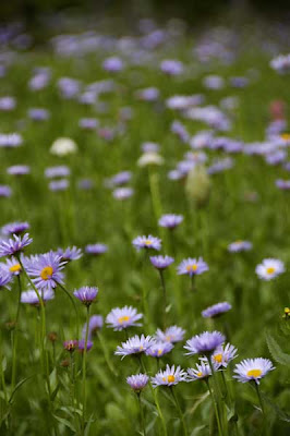
A field of Tall Purple Fleabane...
The ubiquitous LYDF. Little Yellow Daisy-like Flower. Ok, that ID is somewhat sketchy but I can't seem to find it in my nifty guidebook.
The boys tiptoeing through the Numa Pass meadows. Ahmed is standing by a marker that probably acts as a guide for backcountry skiers in the winter.
Indian Paintbrushes come in all sorts of colours ranging from deep red to pink to, in this case, yellow. I read that colour variations are the result of hybridization amongst these plants, but Ahmed says it has more to do with local environmental effects like soil composition.

Ahmed leading us towards the summit of Numa Pass (the scree/snow covered ridge on the horizon)...
Numa Pass and Rockwall in the distance... We lucked out that day. Hardly any wind.
Look, rabbit ears. That Ahmed's a comedian, eh...
The view north showed clearly our destination: the mammoth rockwall in the distance and the Hill from Hell just in front of that. Before reaching any of those features, we had to plunge 830 knee busting metres down from Numa Pass to the Numa Creek Campsite on the valley floor.
My knees were shattered on the way down from Numa Pass but with scenary like this high waterfall who can complain?
I sat beside this slime mold during lunch.
Nearly at Numa Creek campsite...I think the boys were looking for grizzly "bars"...
Felt like it took forever, but we finally arrived at the campsite. Normally, sane people would stop here for the night. But, silly us would march on to witness even more beautiful sights...
After the Numa Creek campsite, the trail was just up, up, up, and more up towards Tumbling Pass. Ahmed dubbed the this stairway to heaven as the Hill from Hell. Suffice to say, the boys, including yours truly, were quite demoralized.
Whenever possible, it was always fun to look back to see where we came from earlier that day. From our vantage point on the Hill From Hell, the dip in the skyline (right of centre) was actually Numa Pass. Indeed, the pass looked rather intimidating, whether one was ascending or descending it. What the hell were we thinking...?
Good grief... when the hell were we going to reach the top of this hill?
We finally reached the lip of the hill. Foot relief for all!! Pass the fresh moleskin!!
Flat landlubbers we were!! We saw our destiny. Just head to the low point at the end of this meadow... It looked like a walk in the park, a piece of cake the rest of the way.
That was until the trail veered to the right. Again, we started to climb relentlessly... In this photo, The Hill From Hell lies below the lip of the bowl in the foreground.
As consolation, we climbed so high that we found ourselves once again surrounded by alpine meadows and wildflowers. Here, Paintbrushes are surrounded by a dwarf variety of Fireweed.
Had the damnedest time identifying these Beefeater-like plants. But they were indeed Western Anemones (Anemone occidentalis). The fruiting bodies are insulated against the harsh cold alpine environs by the fluffy hair-like structures encasing them. The emerging Anemone flowers are nondescriptly white.
The remnants of Tumbling Glacier... the mass of ice was still very impressive. The summit of Tumbling Pass was along this trail but wasn't marked. Suffice to say, from this point the trail would parallel the lateral moraine in the foreground and take us on a 320 m plunge down to the Tumbling Creek Campsite. (It was also here where we met Mr. Roboto, Hiker Extraordinare. He hoped to reach Floe Lake that night. Good luck, eh...)
Hillside shows the result of eons of glacial action.
Ancient tree stump contrasts in stature with neighbouring wispy tamarack trees...
We finally arrived at the Tumbling Creek Campsite at 19:30. Normally, sane people would have pitched a tent at this point but we had no choice to move on. The cabin was waiting for us on the meadows of Rockwall Pass, about 300 metres overhead. As we climbed, "slowly, slowly" became my mantra. Time was on our side believe it or not with the long summer days. We topped out at about 21:00. The photo shows, from the meadows, Tumbling Glacier to the right and the huge lateral moraine (a faint greyish triangular pile of rocks) left of centre that we followed down to Tumbling Creek.
Suffice to say, we were exhausted at the end of the day (21:30).
Not tired enough to scarf down Ahmed's delish pasta dish though.


